Hiking Mount Raung One of Java’s Most Extreme Volcano Expeditions
Hiking Mount Raung is widely known as one of the toughest volcano adventures in Indonesia—famous for its knife-edge ridges, raw wilderness, and a summit crater that looks like it belongs on another planet. If you’re aiming for a challenging multi-day expedition with dramatic landscapes, technical climbs, and minimal crowds, Mount Raung should be at the top of your list. This article provides a full overview of the mountain, the best route to Mt Raung, permit information, difficulty levels, packing tips, itinerary suggestions, and essential FAQs to prepare you for this iconic trek.
What You Need to Know About Hiking Mount Raung
If you want a trek that pushes your limits mentally and physically, Mount Raung (3,344m) is one of the most challenging volcano climbs in Java. Unlike popular hiking destinations like Bromo, Ijen, or Merbabu, Raung demands endurance, technical ability, and the courage to navigate its narrow crater rim. The most popular route to Mt Raung is via Kalibaru—considered the “easier” option, though still extremely difficult—while Sumberwringin is known for being steeper and more remote.
Expect 2–3 days of trekking through dense forests, steep ascents, intense scrambling, rope sections, and ridge-line climbs. This is a trail for experienced hikers or those joining professional guides. The reward? Alien-like volcanic scenery, minimal crowds, gorgeous sunrises, and one of the most dramatic summit craters in Indonesia.
About Mount Raung
Mount Raung is part of the Ijen volcanic complex in East Java, standing tall between Banyuwangi, Jember, and Bondowoso. It is one of the most active volcanoes on the island, marked by its giant circular caldera, sharp ridges, and rugged rocky surfaces.
Key facts:
- Height: 3,344 meters
- Type: Stratovolcano
- Location: East Java, Indonesia
- Known for: Knife-edge crater rim, technical climbing sections, remote wilderness
- Best for: Advanced hikers and adventure seekers
Because of its intense terrain, Raung is considered one of the most extreme hiking experiences in Indonesia.
Best Route to Mt Raung
The mountain has several access points, but two routes are the most used. Each offers a different experience and difficulty level.
1. Kalibaru Route (Most Popular)
This is the standard route to Mt Raung chosen by most hikers because it is the most established and slightly more manageable.
Highlights:
- Well-known trail
- Camp areas available
- Mix of forest, steep ascents, and rocky terrain
- Rope assistance on difficult sections
Difficulty: Very Hard
Duration: 2–3 days
Recommended for: Hikers with some technical experience
2. Sumberwringin Route (More Technical)
This route is steeper and more rugged. It is favored by experienced climbers, especially those seeking a tougher challenge.
Highlights:
- Fewer hikers
- Wild, remote jungle
- More demanding summit push
- Technical ridges with limited footholds
Difficulty: Extreme
Duration: 2–3 days
Recommended for: Highly experienced climbers with gear skills
Hiking Experience: What to Expect
Dense Forest Entrance
The climb begins with thick tropical forest. The humidity is high, and the terrain is often slippery after rain. Expect leeches in wet seasons and limited visibility under the canopy.
Steep Ascent to Campsites
Camp 1, 2, and 3 usually appear before the tree line opens. The elevation gain is demanding, and pack weight matters. Hydration and pacing are crucial.
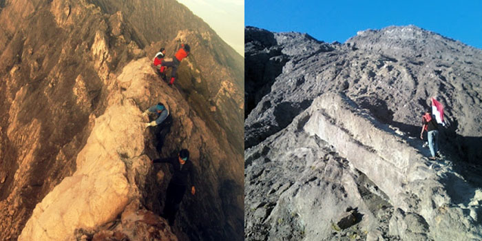
Ridge Lines & Technical Sections
Above 2,800m, the landscape changes dramatically. The paths turn into rocky ledges and crumbling volcanic surfaces. This is where ropes are used.
Key challenges:
- Exposed ridges with drop-offs
- Loose volcanic gravel
- Strong winds
- Narrow pathways requiring careful foot placement
Summit: The Legendary Raung Crater
The summit ridge at Mount Raung is one of Indonesia’s most iconic sights. The enormous circular crater is deep, wide, and active, emitting smoke from its center.
Sunrises here reveal other mountain silhouettes—Argopuro, Ijen, Semeru—making the challenge worthwhile.
Suggested 3-Day Itinerary (Kalibaru Route)
Day 1: Basecamp – Camp 3
- Start at Kalibaru basecamp
- Jungle trekking for 5–7 hours
- Set up camp at Camp 3
- Dinner and rest early
Day 2: Camp 3 – Summit – Camp 3
- Early wake-up at 03:00
- Start technical climbing and ridge sections
- Summit natural viewpoint around sunrise
- Descend back to Camp 3
- Overnight stay
Day 3: Camp 3 – Basecamp
- Breakfast
- Long descent through forest
- Return to basecamp by noon–afternoon
This itinerary assumes stable weather and moderate climbing pace.
Difficulty Level and Required Skills
Hiking Mount Raung is not for beginners. The trail involves a combination of scrambling, rope climbing, navigation across narrow ridges, and exposure to heights.
You’ll need:
- Strong physical endurance
- Comfort with heights
- Basic rope-handling skills (optional but helpful)
- Experience trekking in alpine or volcanic environments
Recommended to join:
- A licensed guide
- A porter (for logistics and safety)
Permits & Regulations
To enter and climb Mount Raung, you must register at the local basecamp. Permits are used to regulate the number of climbers and ensure safety.
Common requirements:
- Copy of ID or passport
- Medical fitness statement
- Proof of climbing experience (in some seasons)
- Attendance of safety briefing
Permit prices vary between IDR 25,000–50,000 depending on the route and season.
Best Time for Hiking Mount Raung
The ideal period is the dry season, when trails are more stable and weather is predictable:
- May to September → Best conditions
- October & November → Transition, sometimes still possible
- December to April → Rainy season, high risk, usually not recommended
Always check volcanic activity updates before planning your trip.
Packing List for Mount Raung
A proper gear setup can make or break your expedition.
Essential Gear
- 40–60L trekking backpack
- Waterproof jacket
- Thermal clothing
- Trekking poles
- Gloves (for rope sections)
- Helmet (recommended for summit day)
- Headlamp with extra batteries
- High-traction hiking shoes
Camping Gear
- Tent
- Sleeping bag (comfort 5–10°C)
- Sleeping pad
- Portable stove
- Cooking utensils
Food & Hydration
- Minimum 3–4 liters of water
- High-calorie meals
- Snacks: chocolate, nuts, energy gels
Safety
- First aid kit
- Whistle
- Powerbank
- Rain cover
- Emergency blanket
Tips for a Successful Raung Expedition
- Train beforehand: Cardio + strength training for 2–4 weeks.
- Stay light: Overpacking is the biggest mistake.
- Use gloves: Protect your hands during rope climbs.
- Follow your guide: Especially during ridge-line crossings.
- Start early: Weather changes fast above 3,000m.
- Respect the mountain: Raung is beautiful but unforgiving.
FAQ About Hiking Mount Raung
1. How hard is Mount Raung compared to other Indonesian mountains?
Raung is significantly harder than Semeru, Merbabu, Prau, or Rinjani. It is often compared to technical climbs like Arjuno-Welirang or the Mahameru summit ridge but with more exposure.
2. Is the crater rim dangerous?
Yes. The ridge is narrow with large drop-offs. Safety ropes and experienced guides are highly recommended.
3. How long does the climb take?
Most hikers complete it in 2–3 days, depending on fitness and route.
4. Can beginners hike Mount Raung?
Not recommended. This climb is for intermediate to advanced hikers.
5. Do you need a guide to climb it?
While not always mandatory, a guide is strongly recommended due to technical terrain and navigation risks.
Conclusion
Hiking Mount Raung is a bucket-list adventure for anyone seeking a raw, demanding, and visually stunning volcano expedition. With its knife-edge ridges, sweeping caldera, and remote forests, Raung offers one of the most thrilling alpine challenges in Indonesia. Whether you choose the Kalibaru or Sumberwringin route to Mt Raung, preparation, safety, and mental readiness are essential.
If you want a climb that truly tests your limits—and rewards you with unforgettable volcanic landscapes—Mount Raung is the perfect adventure.